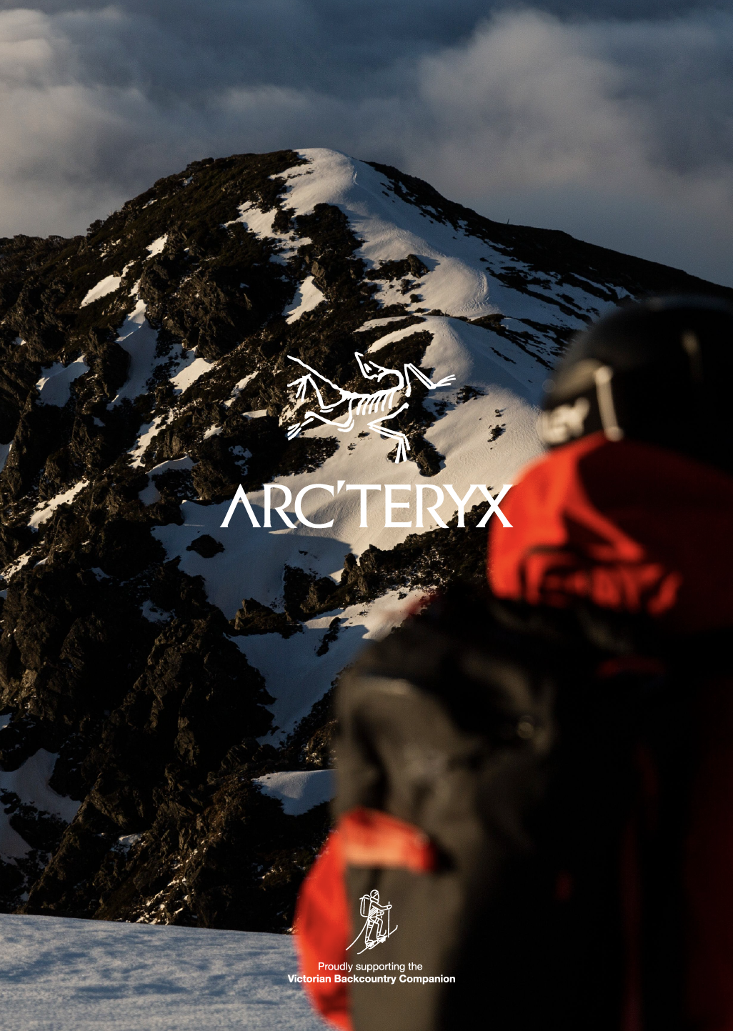
Hotham to Christmas Hill

Master and apprentice, Drew Jolowicz and Orlo Murray ski and skin the glades on Mt Higginbothams east aspect. Entry level backcountry paradise.
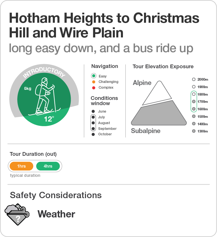

The Victorian Backcountry Companion starts here with the easiest introduction to ski and split touring in the state. Made so through the fact that you climb up a bit, then slide down a lot, then catch the bus back to the top. ‘Slack country - touring’ if such a thing should exist. The tour travels through heaps of fun introductory terrain which will be outlined in the notes below. With lunch at the pub as an extra bonus.
This tour is an enjoyable experience for everyone who is new to either backcountry skiing or Mount Hotham resort or both. It is not a super remote journey through a pristine alpine setting. Some sections are downright sno’burbian. It does skirt some of the ‘famous secret backcountry spots (oxymoronic)’ and as such provides an intro to the terrain on this side of the hill.

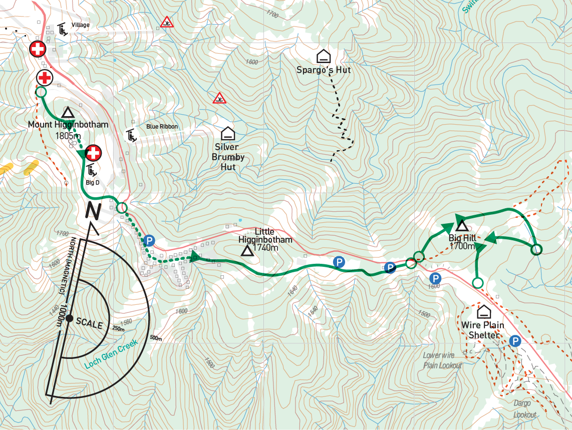
Follow all signs to Mt Hotham out of Harrietville and drive up the mountain. No mean feat in fresh snow conditions. Once at the main village heading down from the summit you’ll find a carpark on the right, The Corral. The south western corner of the carpark is the start of this tour. However, often the carpark is full early. Hotham Resort Management provide a free courtesy bus service (included in your entry fee so get full value) from Wire Plain to this carpark and return. This bus service is central to the tour itself. So if the carpark is full, simply keep driving to the Wire Plain carpark. This has the benefit of having a vehicle at the end of the tour when bodies may be tired and cold. If you are coming in from Dinner Plain reverse the order of this description. You will need to pay resort entry of either $65 same day or pre purchased at $55. Literally pays to plan ahead…
Organise your party to start at the bottom of Lawlers Court (not marked in Gaia). The road that heads up hill between the chalets, not the road that contours south (Higgi Drive).

This tour is entirely within the confines of the resort management area, as such your safety is the responsibility of the Hotham Ski Patrol. It is always worthwhile leaving an intentions form with them at the desk in the building on the far side of the carpark from the muster point, they will be available on (03) 5759 4038 , also check the daily conditions report issued by ski patrol here. Mobile reception is strong all the way from start to end. In an emergency call 000, but its likely Hotham Ski Patrol will be the first responders regardless, so it makes sense to call the number above as a follow up.

There are some flat sections on this tour, so both skier and splitters will suffer them equally. The down hill sections are thankfully long with a consistent pitch, so with fresh wax, carrying speed will see you prevail if the snow is slow. The tour notes cover appropriate locations for transitions. You can do this tour in any mode from skating, light tour, telemark through to heavy frame bindings and or snow shoes and board combo.

Thankfully given the close proximity of the resort you can’t go too far wrong here. With the exception of the first few hundred meters the route is well landmarked, then groomed all the way. If in doubt retrace your route to safety / familiarity.
Tour Notes
The Corral to the Water Tanks.
Skins on and uphill ready, scootch up the road left of the ‘Last Run Bar & Cafe’ and then the Alpine Heights chalet. From here contour around the open bowl (known as Lawlers) past the MSC Avalanche Beacon Park to the trees beyond. There are some open pools in the creek here and they need to be avoided by skinning downhill slightly. With no snow there is a ‘Fire road’: R2N (Road to Nowhere?), much less obvious in winter. Follow it briefly down around a tight grove of gums before making a long gentle uphill traverse through the glades. Zigzagging as required to avoid the dense gum groves. Finding gaps in the gum groves is sometimes troublesome depending on how laden they have become with after fresh snow. A good problem to have really.
Ultimately all the open gladded gullies lead uphill to the broad summit ridge of Mount Higginbotham (Higgi). You may arrive early onto the summit ridge (well North or the water tanks) and find the tourist shelter and picnic table, so keep heading south. Or you may make the top later, further South and East, and arrive on the ridge with the water tanks in view. If your party ends up in steep ground (Over 15˚) you need to turn back and zig-zag up hill to the tanks which are directly above. The water tanks are huge industrial scale installations and you cannot miss them. The total distance to the tanks is not more than 300m from the trail head. See the note below about ‘Sucker Tracks’.
From the water tanks travel south and east across the broad flat summit ridge to the Ski Patrol Hut and Ski Lift unload station above the ski run (Big D). Be sure not to travel Eastward as the eastern side of ‘Higgi’ is flanked by steep faces which have a well earned reputation for avalanches, a symptom of having a reputation amongst resort people that these faces are good for cornice jumping. Stay clear.
Sucker Tracks: The area South of the trail head and West of the water tanks is referred to as Women’s Downhill and the Brides Spur. This is an extensive and challenging ‘advanced’ backcountry area largely only suitable for Level 3 participants. Many ski tracks you will cross on this tour will be heading into and out of this area so be mindful to follow the ‘companions’ directions here in the Tour Notes and don’t assume other previous parties in the vicinity share your objective. Follow the directions given, even if it requires making new tracks.
Extra curricular activity: Keen to cut a quick lap? The most obvious of the continuous gladded areas starts just west of the aforementioned picnic area (1790m) and keeps skiers right of the drainage / gully to an elevation of 1720m where it follows a subsidiary ridge that juts out from the surrounding hill side, beyond and below the ‘Fire Road / R2N’. Below 1720m the only open glade steepens to 25˚ and falls off to the south east flank of the ridge known by some as ‘Dead End’. This is prime avalanche terrain with a deep terrain trap at the base. No place for Level 1 and 2 participants.
Big D, The General and Davenport Village
Behind the Ski Patrol Hut, transition to downhill mode. Beware, Big D is Mount Hotham’s beginner area so be mindful of beginners and ski/ride as always, in control and avoid others. The tour follows the skiers right from the lift out around west side of the steep peak. All ski paths ultimately lead down, past the bottom of the ski lift and into the trail leading down to the road and The General (The Pub). Sure, stop for some refreshments! Why not… it’s the only point in the ‘Companion’ that you can, so you might as well right? Or not…
On the trail, keep travelling South and East, along what is now Davenport Drive. Welcome to sno’burbia. And, as is the case anywhere, it’s boring. A flat 600m haul to get away from the throng or snowmobiles, snow men and tow’bogans’. Transition to skins? Not sure, it’s real flat but a long skate.
Take a right at the end of the last straight, skier right of the play equipment, and the intersection of Davenport Drive with Ash Drive, better known as ‘Poo (farm) track’.
Little ‘Higgi’ to Christmas Hill.
From the junction here, this tour takes the groomed trail down hill in a South East direction for 600m to the ‘Machinery Sheds’. Follow the groomed trail along a flat behind the sheds before anther short drop down to the intersection with the road.
The elevated ground beyond the play ground and on the skiers left and right of the ‘Poo Track’ is Little ‘Higgi’ (Higginbotham). ‘Little Higgi’ is an intermediate to advanced backcountry area with a some steep avalanche prone aspects on the East and South faces, including the area below the track behind the machinery shed. Stick to the groomed trail here folks…
Cross the road here, where the groomed trail commences again on the opposite side. On the other side turn right at the fork and continue on in an Easterly direction (1650m elevation). The track begins to ascend, transition here to uphill mode. Up and up, continuing along what is now the ‘Christmas Hill trail’ taking all the left forks. Eventually you will gain the summit and the picnic table.
Christmas Hill.
Transition here at the picnic table and get ready for the down. Heading west from the table taking care as the trail is noticeably narrower/tighter than all the groomed terrain travelled thus far. Take the left lane at the fork. Both options reunite just 50m further along. Then at 1620m elevation you will draw to a halt on the flat ridge top. Look skiers right (south) and you will see an open gladded area. The tour heads down ‘off piste’ here and descends across a maze of XC trails to the bottom of bowl where the trees close in. Mindful of the possibly exposed creek in the gully at around 1630m elevation. What a hoot! Usually, once the skin trail is in, back to the top the kids I know (some in their 40’s) will cut a few laps, enhance a berm or a lip here and there… before making for the Car Park at wire plain via the middle trail (not the low one, or the high one) on the east side of the open area. This climbs back up to 1660m, transition here and enjoy the last run down to Wire Plain.
Depending where you park the car either finish here, or jump on the bus and return to Hotham Central and the Corral CP.