North Bogong High Plains:
Mount Nelse and Edmondson Hut + Bonus Extra Tours
Extended Tour: 2+ days

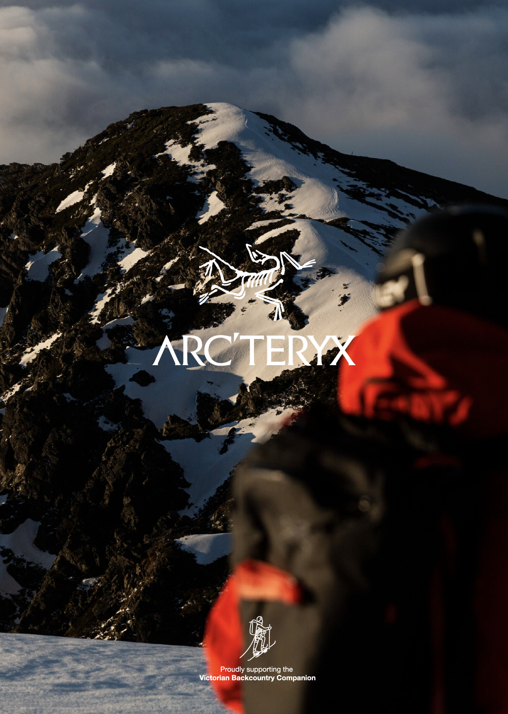
Mt Nelse: Victoria’s third highest peak, a massif really… with three peaks above 1880m.
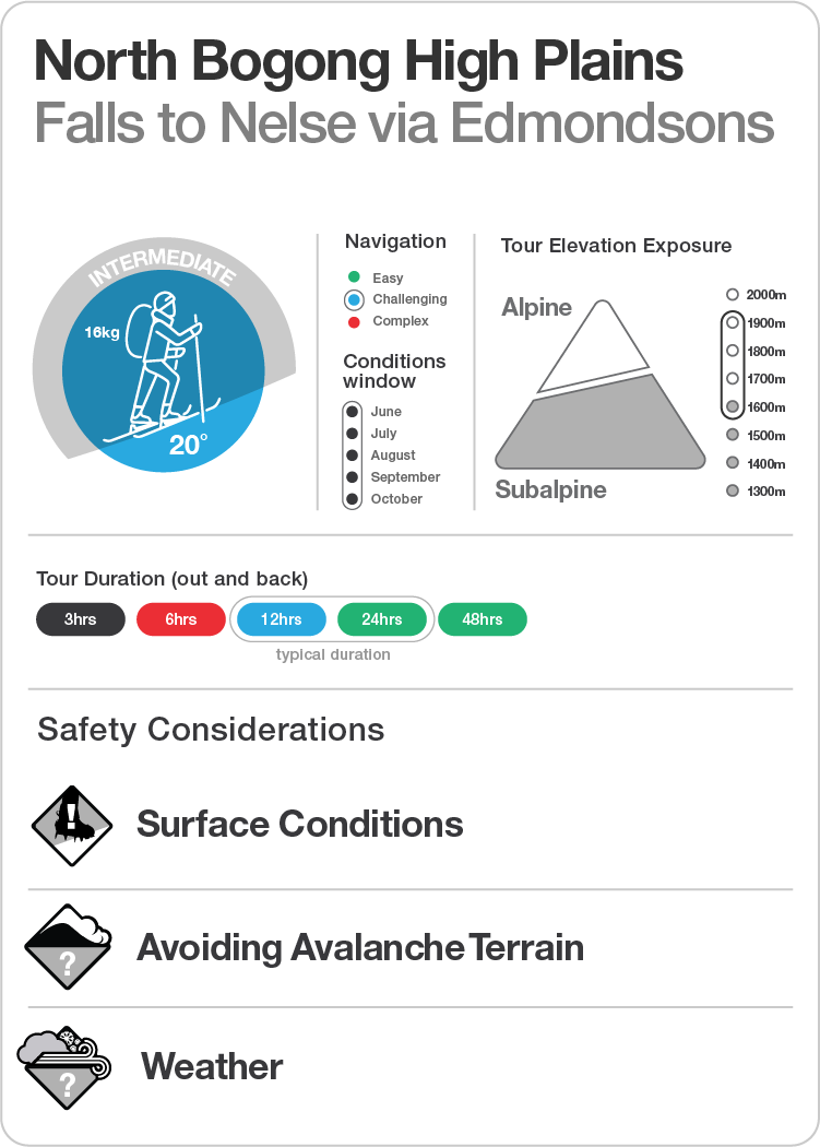

The tour from Falls Creek to Edmondson Hut is the beginning of a larger traverse of the High Plains, the ‘High Plains Drifter’. It has been included as an intermediate overnight tour as it offers a hut, in reasonable distance from the trail head, and is surrounded by a variety of day objectives (which constitute the HPD tour). Pretty popular playground for those who are keen to clock up big vert on generally mellow terrain.
Described is the route out from Falls Creek to the Edmondson hut. This tour is a good follow-up to parties who’ve explored the Watchbed Creek tour as is travels parallel to that terrain. Given the elevation, the tour is exposed to the elements and the majority of the distance travelled is in the Alpine. Parties are regularly ‘pinned down’ in the hut, so it’s not a place to travel to if there’s inclement weather in the forecast. Huts in the Alpine National Park are for emergency shelter and must not be relied on for accommodation, carry a tent!

This tour starts out from Windy Corner Car park. Windy Corner is located at the end of the road at Falls Creek Alpine Resort. Parking here will require an entry fee for as many days as you are visiting. The resort entrance is at Howman’s Gap 6km down the road. Howman’s Gap is also the location of the YMCA centre and a very ‘backcountry friendly’ venue to base yourself from prior to and following your tour if needed. Accommodation is dorm style, cheap and cheery and the perfect place to use as a base for adventures in this area. More info here: https://camps.ymca.org.au/howmans-gap-alpine-centre

As with all the tours on the Bogong High Plains, emergency contingencies are good here with the SES Alpine Rescue team based at Windy Corner. If something goes wrong, rescue resources are close at hand. As always call 000 on mobile, request ‘rescue’ and then follow the instructions. Falls Creek Ski Patrol are ready at hand also within the vicinity of the resort boundary (up to the dam wall), so if you are feeling broken, but not actually broken, call them for assistance: (03) 5758 3502. Mobile reception isn’t great based on most recent observations. If this is the problem dispatch someone to raise the alarm from anywhere with line of site to the resort like the top of Home Hill or Heathy Top.

The tour is described to suit alpine touring, NTN telemark and split boarding disciplines. The Kangaroo Hoppet XC ski race laps the Heathy Spur and while you may be ‘buzzed’ on the flats by the Lycra clad set in training, beyond Heathy Top their presence ceases, as do the groomed XC trails. Some of the terrain at Home Hill, The Three Peaks Circuit and The Keep is borderline avalanche terrain and to be avoided during periods of ‘considerable’ to ‘high danger’. You should always check the daily conditions report before venturing out. Avoid aspects of concern. This region is geographically prone to hard crusts through to bulletproof ice. Ski/split crampons are advised.

Reckoning (knowing where you are)
Beyond the resort, following the ascent of the Heathy Spur out beyond the Dam Wall, navigation gets challenging. It’s very easy to become disorientated out on the High Plains even with the aid of snow poles when visibility wains. The Big Hill Fire Track works as an emergency (escape) ‘handrail’, never more than a kilometre distant in a south east direction, and as such is sheltered and downhill from the top of Heathy Spur. The outward journey from the Dam Wall follows a bearing of east-north-east (roughly 50˚) all the way, while the return is west-south-west (roughly 230˚).
Wayfinding (connecting the dots on a map)
We strongly recommend the MSC Bogong High Plains map and compass en-route in conjunction with either the 1:25000 Vic Map sheets (yes, there are two) or plenty of back-up charge for your GPS or Phone using our GAIA plot here for emergency reckoning (aka. when you are lost). Do not rely solely on digital navigation in the backcountry. The cold temps are brutal on the charge rate of your devices. Always turn devices off when travelling as they can interfere with avalanche beacon frequencies.

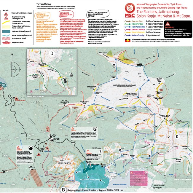
The Fainters, Jaitmathang, Spion Kopje, Mt Nelse & Mt Cope
Bogong High Plains map and topographic guide to ski touring and mountaineering.
Bogong High Plains Road: Windy Corner to the Dam Wall
Assembled at the trail head, nice and early ready for a big tour (8am is a good start time) with skins on and uphill mode ready. Head out along the Bogong High Plains Road (BHP RD), in a southerly direction. This is pretty straight forward, being mindful not to take up trail space for the XC scene. Eventually you will come to the Nordic Bowl. This is a place where the XC races are staged. Skin through the bowl and exit the other side on the broad south west trail signposted ‘Dam Wall’. Soon after you can see the wall and the where the trail crosses. Cross on top of the Dam Wall.
Parks Shelter to Nameless Knob
Having crossed the Dam Wall, dead ahead is the Parks Victoria intentions book and shelter. Fill out your intentions with all the relevant details. Now turn south east and follow the BHP RD only 100m before launching uphill on the skier’s left. More often than not, there will be tracks, if it’s fresh snow, perhaps not. Ascend this slope aiming for the ridge at a point around elevation 1660m above the road. This is Village View Saddle. You will find a groomed trail in the vicinity heading up and west to the top. Keep your heading 50˚ for another 1km as you make for a forested high point at 1730m elevation. You can choose to continue on skins or transition at the edge of the glade beyond for a short slide (30m vert) over 200m to the bottom of the small bowl. Stay on the heading 50˚ and transition if you chose to ski down.
Heathy Tops to Edmondson Hut
After a slow very gentle climb of 80m vert over the next 1km, you ascend the highpoint at 1780m on the edge of the plateau. Beyond this promontory you can see the larger flank of Mount Nelse South Face.

From here you can again transition, this time for a longer descent. With any luck the view should look like picture above. The hut is obscured within the gum grove on the south face of South Nelse. A long arcing skiers rightward traverse will land you at the bottom of the Nelse Creek basin from here. From below the gum groves transition and ascend favouring the skinners left hand side of the grove to Edmondson Hut.

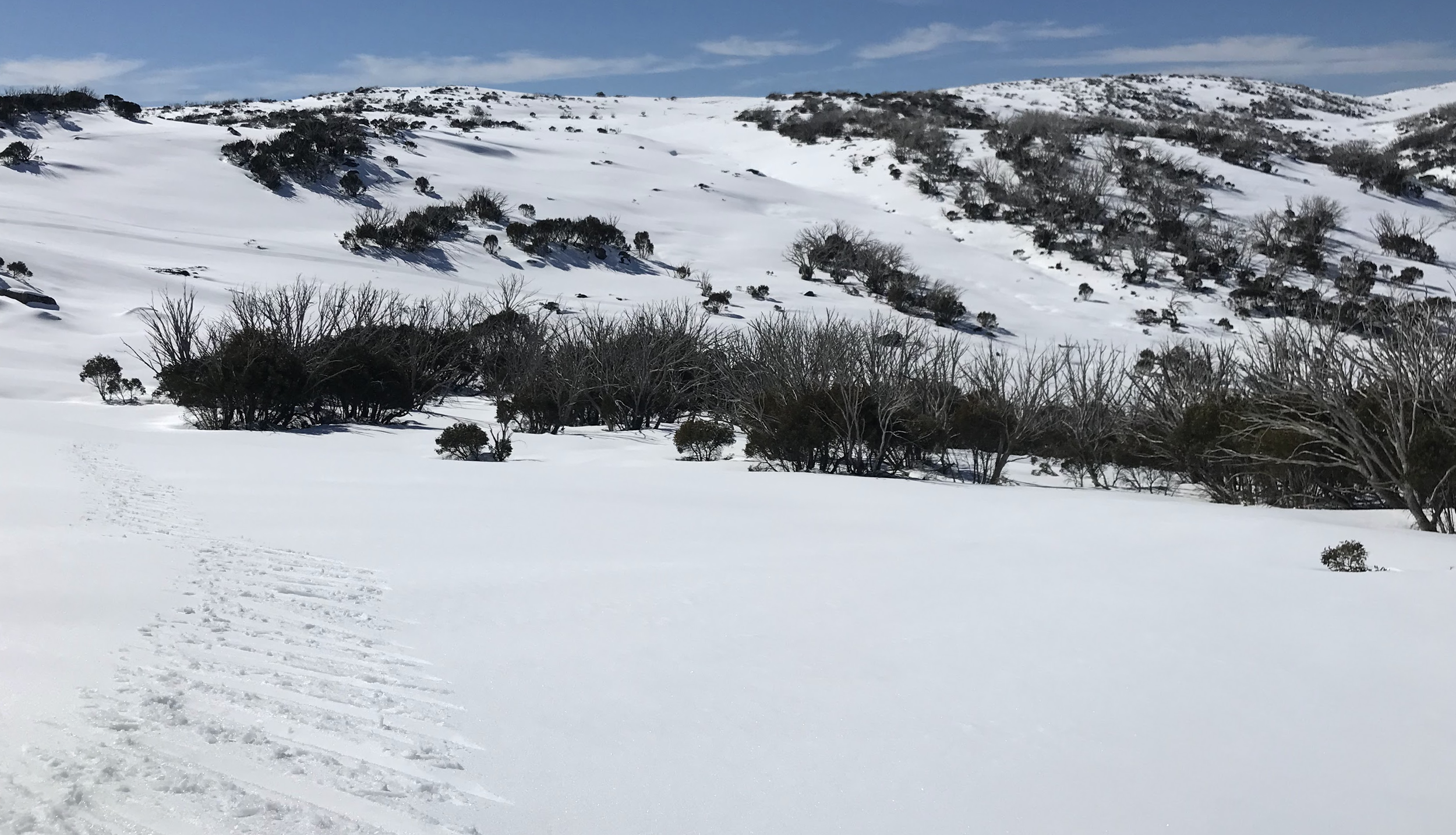
From Heathy Top, it’s worth noting the Big Hill Fire Trail on the skiers right (east of the Heathy Spur), an easier escape in less than perfect conditions. The area shown is referred to as ‘The Park’. Snow poles all the way home….
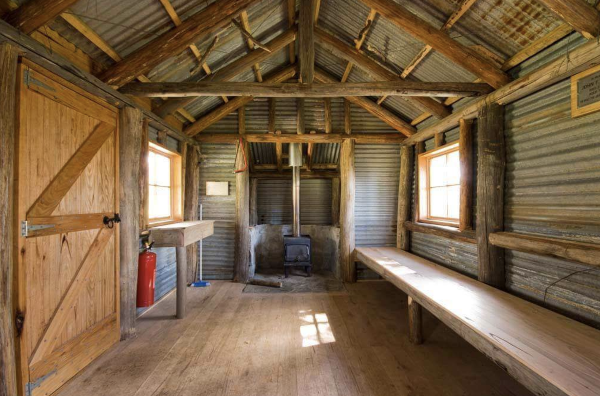
Edmondson hut. Utilitarian and practical. Image courtesy of ‘Mr Tee on XC Skis’ from a great pictorial trip report at Ski.com.au
Edmondson Hut
Edmondson Hut is a cattleman's hut on the Bogong High Plains. Jim Edmondson obtained Run 33 (near Mt Nelse) in the early 1930s. He pre cut the timber at his property in Tawonga and along with iron for the walls, chimney and roof, took it up to the Bogong High Plains on pack horse. The hut's wall and ceiling were lined and the hut had a 'fairly good floor and bunks'. In 1971 the hut was donated to the Education Department and was approved for transfer by the Lands Department in 1974. Bogong Outdoor School camp was then using the hut for students to camp in. The hut is now a public use facility administered by Parks Victoria.
There are a couple of bunks, a table with stumps as chairs and a fire at one end. As always, leave the place better than you found it. Stock up the firewood, don’t put waste scraps in the toilet and carry your rubbish out (goes without saying). The resident mountain mice have as much if not more right to the place than us so don’t endanger them, they are having trouble as it is.
Ed’s Creek, Home Hill and The Keep
West of the hut is a large bowl created by the Edmonson’s Creek (Ed’s Creek) drainage. The rise on the ridge above this is Home Hill. Home Hill and the Nelse’s south flank are collectively referred to as Bakers Spur. The ridge running south of Home Hill divides ‘The Keep’ from Eds Creek bowl and is usually the pick of the spots first up where its east aspect warms quickly on a clear spring day. The rest of Ed’s Creek can be challenging as it is slow to soften, scoured and icy. In the grips of a melt freeze cycle its likely that finding east and north aspects will be the only option for fun skiing/riding.
During the passage of a low pressure system , the constricting valley wind effect of the Nelse and North Nelse creeks either side of Bakers Spur can be severe and the only place where you can see what you are doing are the well sheltered timbered areas. When it’s snowing you won’t need to go far as the glades where the hut is located provide ample opportunities for hunting stashes. Similarly further west, The Keep provides some deep immersive experiences, not just the snowy kind, as the steep short drop to the creek at the bottom has a small elite ‘swimming club’ associated with it. Watch out for the creek at the bottom. Also isolated steeper terrain features must be avoided during periods of heavy snowfall and the resulting heightened avalanche danger.
Extra Curricular Itineraries: Bonus Extra Tours

The view South from Mount Nelse South is as expansive as any alpine vista you can glean on the mainland, with close cousin Mount Bogong on the right all the way out to Buffalo and across the Dividing Range to the Dargo High Plains. A worthwhile effort if the visibility gods are on your side. Note the typical shiny bulletproof ice conditions and travel prepared.
Three Peaks Circuit
This neat little jaunt packs a heap of vert into a relatively short distance with the added bonus of ‘Maisie’s’ which is probably the longest intermediate ski run in the country with 250m of vert at a consistent 20˚angle from 1890m to 1640m

Connecting the three peaks of the Nelse Massif is an obvious day tour objective from Edmondson Hut. It can be done any which way and has become something of a ‘Race Course’ for the competitive tourers (the ‘SkiMo Crowd’) as it packs as much vert as you will get anywhere with the option to ‘go deep’ on every descent/ascent. The GAIA plot provided here leaves the best for last, Maisie’s Drop, and with any luck the longest period for some solar radiation to soften the south aspects.
In brief, climb to the South Nelse summit from the hut, transition, point tips north or north west depending on how deep you want to go into the Nelse Cirque before turning, transitioning and heading up North Nelse. From that peak head west, again finding a line between heading at the objective West Nelse (Maisie’s Knoll), and travelling forward downhill, transitioning somewhere in the vicinity of 1800m mark. Maisie’s Knoll and the south face ski descent are named after Maisie Fawcett. A visionary ecologist and environmentalist, prominent between the wars. Her methods and observations are still being used today on the High Plains.
Maisie’s Knoll (West Nelse) is the third highest point in Victoria, only discovered relatively recently with laser technology…who would’ve thought huh?
Anyhow… skins away! Ski the glorious face to pick up the tree chute at 1730m and follow this down to the creek. Cross over, transition and find some motivation for the 250m climb back up and out along ‘Sun Bakers’ spur. You wouldn’t be the first to promptly turn and enjoy the sunny ride back to the valley floor for a ‘quick lap’ to finish the day… before scootching across the flat saddle to Home Hill and the descent to Edmondson Hut.
Spion Kopje
You’ve got to give the people what they want! And strangely Spion Kopje is a peak on many peoples bucket lists. Probably highly sought after by ‘Falls People’ who look across the valley from the ski lift and resolve ‘One day!’.

Spion Kopje from Orbit Bend, Falls Creek. So close, yet sooo far.
Problem is that it’s a real real really long way around to something that looks so close to the resort. The up side is that it has good long ups and downs and suits Splitters and Skiers alike. The peak itself is all pretty advanced terrain and often very challenging given its south aspect. ‘When the Face of Spion is ready to ski, it’s a bushwalk out to get some’ is the famous anecdote. This tour is roughly out and back with ‘Maisies’ summit and run included for extra bonus burn. This is a very big day! An early start for this one

1760 Traverse
Start by heading north up to the top of Bakers Spur from the hut. A quick transition at the shoulder ahead of a looooong traverse initially north eastward to elevation 1830m, then swing north through to west to elevation 1760m. This is the ‘1760 traverse’ and the crux of the route. Its purpose is to save the time of travelling over the tops, when it works its great. Some parties have chosen to do it at 1720m in the cover of the trees, others ended up in the North Nelse Creek, rejoining the route at the tributary. It’s likely that the snow will be firm to very hard. If the surface is ‘bulletproof’ and unyielding to ski edge it’s wise to pull up short, descend to a safety island and retreat. The key here is that you need to hold a high traverse to get the maximum gain westward, so firm conditions are your friend. Judging when this will be given the surface conditions and aspect is pretty ‘advanced’ for an intermediate party so be observant and work out contingencies.
Once the crags appear, hopefully below and left of the leader, it is time to transition (again very tricky in firm conditions). Commence an uphill traverse to the mellow ground on the shoulder. Gain enough height to make a descent on a line west down the ridge initially then onto the shoulder to descend to the tributary gully.
From the gully, transition and commence the 2.2km gradual hike up to the Spion Kopje summit. High fives all round and a wave at the resort before skiing back down that 2.2km ridge. A pretty fun cruise. Backtrack, with the exception of adding the Nelse West (Maisie’s Knoll) summit and return via Maisie’s Drop as per the ‘Three Peaks’ tour description.
Ropers Hut
If you, like many are actually just in this game for the huts, then this tour, an addition to the Edmonson tour turns the trip into a minimum three or four night sojourn. Importantly Ropers Hut is mint!

Ropers Hut: image courtesy of SJM@ski.com.au
Ropers inside: Murray Valley Bushwalkers
The tour from Edmondson is really straight forward in that there is a road and a snow pole line that lead all the way there. The road is engineered to milk the ‘flat’ from the terrain, and you know us… we milk the steep from the terrain so the GAIA links here and description are simply alternative routes to following the road that prove efficient across the ground given the advantage of sliding rather than walking. If things get hard or weird, the road is the navigation handrail. Grab onto it and use it out and back if needed. Day trip or super easy overnighter.

Simply head north east out of Edmondson Hut. The pole line you encounter at elevation 1850m is the road to Ropers Hut (Big River Fire Trail). At a distance of 1km from here you will find a junction with the Spion Kopje Road, stay right at the fork on the Big River Fire Trail. Another kilometre further is the intersection with the Australian Alpine Walking Track, this is the route you take to Roper Hut (signposted). Although if you followed the alternative GPS routes you will have cut this corner entirely. The hut is located at elevation 1710m in an conspicuous isolated grove of green snow gums.
West of Ropers Hut is the Duane Bowl which is worth a poke around for some easy sunny glade skiing. T spur is the continuation of the route past Ropers Hut and leads down across the valley to Mt Bogong.

Back to Windy Corner
Wow… So much to explore. To return to Windy Corner (Falls Creek) from Edmondson you can retrace your outward journey. Follow the road back along the pole line, or make use of the East Heathy Bowls and get maximum slide for your journey home. This descent is detailed in the GAIA plot and will require a short scootch (skate/climb/hike) to sneak over the saddle mid slope on Heathy East. With a little careful planning and a highest of high traverses it is possible (in firm conditions) to get all the way to Windy Corner from Heathy Tops without transitions (perhaps some double poling though).
Looking back over the skiers shoulder at the ‘scootch’ section on the return to Windy Corner, out from Heathy Tops. Reminds me a bit of this