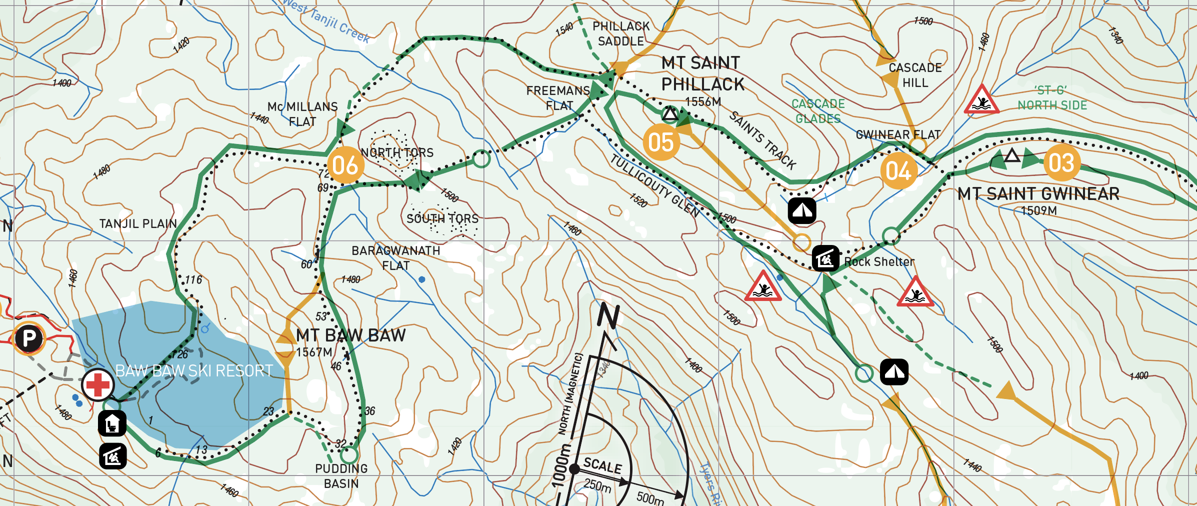
St Gwinear to Baw Baw: Trailhead to ski village and return

The Baw Baw Plateau is an often forgotten sub alpine wonderland, with a few hidden perks.


Background
The Baw Baw plateau is an elevated Granodiorite intrusion with summits at around 1550m and high alpine meadows at around 1400m. The name Baw Baw is believed to be derived from the local language of the Gunai Kurnai meaning ‘Echo’. Although on early maps it’s named ‘BO Bo’ which is local language for ‘Big’ which certainly from the perspective of their country it fits the bill, being the highest, largest and southernmost such massif on the mainland. The first nation people purportedly avoided the higher plateau and denser forest areas in favour of the open plains where game was more plentiful, although they did visit the plateau in the summer to hunt and to collect Bogong Moths for food.
The first European exploration of the Baw Baws appears to have been named by the botanist Baron von Mueller, 1860. He named Mt Mueller and Mt Erica. The earliest tracks were cut, no doubt along the existing pads of the traditional peoples, way back in the 1890’s. As was the practice for ‘Surveying’. In the 1950’s the fledgling Baw Baw ski resort was clawing its way up the mountain. Meanwhile on the other side of the hill an enterprising nutter with a dozer had taken it upon himself to cut a road over the top. Apparently and luckily the local authorities were alerted and the rogue road building ceased, an act which coincidentally was a part of the momentum behind the national parks lobby which followed. A case of bad, making for good. This is the road, the St Gwinear Road is where we begin.
This ski touring venue is the southernmost in the ‘companion’ and as such’ this place can light up in an instant with the advance of a deep southerly depression. To capture the magic of the place it is worth staking it out as a season starter. June can be game on and usually the chances of booking a bed in the resort for an overnighter (particularly mid week for a ‘sick-day’) are very good. In this tour itinerary we suggest travelling light and fast with pattern base skis, or better still just ‘kicker’ skins. The idea is to race across the top of the plateau from the St Gwinear trailhead to the ski resort. Sleep at the village for the night and return the next. It’s an introductory tour that lets you cover lots of ground with light packs and focus on technique. It’s two back to back 9km/350m days.

The haul out to the Baw Baws follows the Princes Highway M1 to Moe. Here you’ll turn left and wind through the backstreets to cross the Latrobe River and wind on up the hill towards Erica township. Seninis Campsite is located 800m off the road on the left heading up, this is a shady flat on the river bend of the mysterious and tasmanianeque Tyers River. On the crest of the ridge, you pass Erica, a cute logging town with a thriving love of felling timbers. The pub here has some motel accommodation which is pretty good when washed down with some tasty grub and a beer. Just keep your politics in your back pocket and your flanny buttoned up! Note, a night spent here for an early ‘light and fast’ start is a very good idea. If there is snow in the main street in the morning, you are in for a good time on the hill.
Beyond Erica you pass Rawson and the turnoff to Walhalla. The colonial history in the area is the driver to local tourism and if you want to sample a bit, then Walhalla is truely a step back in time. Next is the turn off to Mt Erica and then St Gwinear respectively from the main Thompson Valley Road. Follow the signs to Mt St Gwinear. Or just google it…
The St Gwinear road is the ‘backcountry’ gateway to the Baw Baw plateau. Whilst it is further in distance from Melbourne, it is free compared to the Baw Baw village, and as such enshrined in the ski bum lexicon as a ‘Good-get’. Google has you there in just under 3 hours from Melbourne, the same as Baw Baw Village due to the steep winding ascent on the village side.

There is a system of snow poles, if you follow any of these, you will end up at either end of the tour. There is a rock shelter on the saddle below Mt St Phillack for which provides marginal protection.
St Gwinear side: There is a voluntary ski patrol who work on the weekends and sporadically outside that. For anything serious, even just late and a bit lost, call 000. Rawson Police Station is very nearby on (03) 5165 3444 and if you self extract but feel like you could do with some medical treatment Rawson Health Centre is on (03) 5165 3236 or La Trobe Regional Hospital on (03) 5173 8000. Local conditions, 24hr snow, road and weather report on
(03) 5165 3481.
A vast expanse of spotty modile reception exists on the plateau in the glades before Mt St Phillack so aim for there as a comms contingency.
Baw Baw side: The ski patrol are on every day and conduct sweeps as far out as Mc Millan’s Flat at the close of operations. Call them on 0448 818 928 and they might even scootch out to help out if things get grim. Side note: word has it that Baw Baw ski patrol don’t take kindly to skinning on the pistes so let’s play nice kids…

Baw Baw plateau offers its visitors an intimate and gentle interaction, so ski accordingly. It’s not a place for big steep burly fall line descents. In exchange it provides touring on low angle technical ground which is very much fundamental skill for many of the tours covered in this guide and still has plenty of down (700m). As such, and one thing worthy of mention is that the place really isn’t well suited to split boarding. For the splitters out there, who want to glean this experience, grab some hire ski touring kit and get that skill, or wait for a deep cold depression and head straight for Mt Erica for something very adventurous (see page XX). You can take anything from light skate gear, ski-mo race to regular tech binding touring gear. Frame bindings would be a stretch though as weight saving is key. Kicker skins are about as much traction as you will need. No avalanche danger, icy but not steep… just watch the weather.
1. Mount St Gwinear Trailhead

The Blackwoods give the trailhead an almost Canadian flavour.
On weekends during the snow season there’s usually a scrum of wet ’boganists getting amongst it. The broad gravel carpark concludes at a gated 4x4 track. Skins (or not if you have pattern base skis) on here and up we go. The trail leads up through the tall forest stands of Blackwood, until after 2.8km it reaches a sweeping left hand bend.
2. Jeep Track Flat
This is Jeep Track Flat just above 1440m elevation. Jeep Track flat is a vague saddle on the ridge at the point where the snow gums gain prominence. The views to the right on the ascent extend, on a good day as far as Mount Speculation some 60km distant.
Continue onwards and upwards on the main trail, as this crests a broad ridgeline. A pole line arcs off to the right. This traverses below the St ‘G’ summit to the plains beyond, but the goal should be elevation and the summit, upwards, always upwards to the summit.

3. Mt Saint Gwinear Summit or MSG for short.
Mt St Gwinear Summit. That’s it, you are standing atop the equal fourth highest summit on the Baw Baw plateau. A great achievement as a first foray into ski / split touring. A stunning summit if the conditions permit a view, or a hostile exposed knoll on this southerly extremity of the range. After a quick transition heading WSW along the ridge below the summit, an open meadow is gained.

The view South West from MSG toward St Phillack and the meadow below
Or the super simple version

Freemans Flat via the rock shelter.
This is where there are is an abundance of options. Waypoint 5 on top of Mt St Phillack is central to all of them as a reference. The preferred option to create a true loop would be to continue South West the from the summit, down across the meadow and into the forest beyond. Nestled on the ridgeline you will locate the rock shelter. Take a moment here, the half way point, to consider options, look at how long it has taken to get to here and if need be, turn back if its getting late. The downhill to the car from the MSG summit is only a 20min rip yet its another hour or more to the top of the resort.
Onwards? Ok, now head down hill a little continuing South West the West into another wide meadow. Follow this uphill along the flanks of Mt St Phillack along what is known as Tullicoutty Glen to Freemans Flat.
Camping Out: Any of the meadows provide suitable overnight camping spots if that is your plan. It’s a good plan if overnighting is on the agenda. The flattest spots are marshy so it is a good idea to camp just up hill a little where you will have a firmer base.
Freemans Flat to Baw Baw Village (Orange Poles)
From Freemans Flat head South West to the saddle across the ‘glen’. From here its another dip in the same baring South West to the groomed trail that loops the resort. Waypoint 6. You are now in the resort boundary and it’s all undulating but generally down hill, very gently, to the resort. Check-in, dry off, rest up.
Baw Baw Village
This is a cute little ski village with a modicum of dining options, and some great relatively cheap accomodation options. Lift passes are available and if you want to take a day on the tows this is an excellent place to cut downhill laps again at a relatively cheap price point. As noted earlier, here the ski patrol take particular exception to skinning on or near the piste so if you are touring stick to the XC trails.
Back up to the top
Look for the signage to the XC Village Loop trail, the eastern side you descended earlier, now you are looking for the western continuation. The grind up the hill is straightforward all the way to the top with a few side tours yet all roads lead to the ‘National Park Junction’ at Mc Millans Flat. Here take the Tanjil Trail (Snow Poles) back to St Phillack Saddle.
Saints and Cascade Trail to Jeep Track Flat
(Blue then Yellow poles)
This is the beginning of the descent to the St Gwinear carpark. 5.5km Kilometers of gentle downhill (with a few flat spots), as long a run as you will find in the backcountry anywhere in the state. 350m of drop along the way. Fun numbers. From St Phillack saddle the trail contours on the north side of the summit ridge. You can quickly scootch up to the Mt Saint Phillack summit from the saddle. The summit is marked with rock cairn, unfortunately no views due to the snow gums surrounding it.
Following the Blue Poles down after a hundred meters or so, the trail opens into a delightful glade. Watch out for sink holes in the middle. Then the trail follows the skiers left bank into St Gwinear Flat.
Now follow the yellow poles along the Cascade trail. This contours gently down hill to the jeep track, then it’s on for young and old back to the gated Trailhead where you started.