Pretty Valley and the ‘Rockies’

Happy day tourers summiting on the North Knoll, almost ready to transition and ski into Pretty Valley.


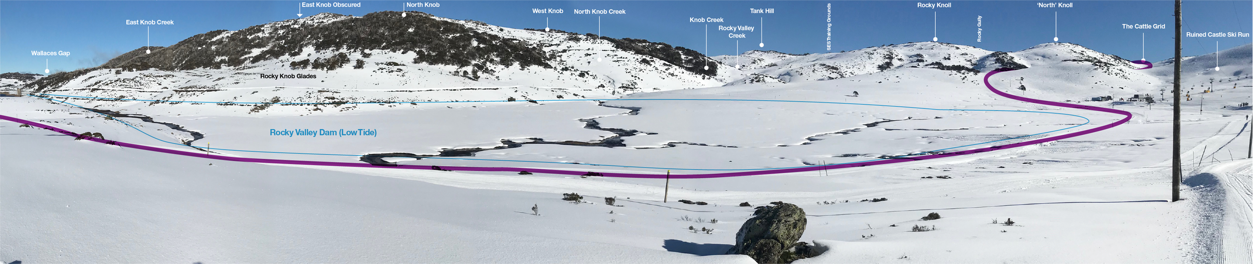
Welcome to the ‘Rockies’: The Rocky Knolls on the right, the Rocky Knobs on the left… as seen from sun valley road Falls Creek.
The Rocky Knolls and Rocky Knobs are the mountain range visible across Rocky Valley Dam from Falls Creek ski resort. The valley between the Knolls (North) and the Knobs (South) is the upper tributary of the Rocky Valley Creek. Collectively referred to as the Rockies! What the Rockies lack in verticality (particularly by comparison to their North American counterparts) they make up for in variety. This affords the visitor the ability to seek out the best aspect, be that sheltered south stashes or sunny corn fields to harvest.
In these tour notes we will cover the ‘Pretty Rocky’ tour loop. A circuit that takes in most of what the area has to offer in a short 7km loop. This loop can be done in either direction. Central to the tour are two key features, the Pretty Valley Road and Pretty Valley Hut. The road provides a navigational handrail, accessible in even terrible conditions. It also means that a Pulk (fancy Euro name for a sled/toboggan for your gear) can be employed with significant advantage. Almost to the extent that for overnighting you are crazy if you don’t use one. The hut puts the ‘emergency shelter only’ back in perspective as there’s no way you can sleep in this thing… measuring 3m x 3m. Importantly the stove works well and is a god send in wet conditions. Lastly we will also cover the controversial topic of Road 24 access. It’s a big haul but its free!. And if you are headed out for more than 3 nights that’s almost the entire catering budget saved in car parking fees. Always breaking down the details to a dirtbag level here at the Companion!

This tour starts out from Windy Corner Car park. Windy Corner is located at the end of the road at Falls Creek Alpine Resort. Parking here will require an entry fee for as many days as you are visiting. The resort entrance is at Howmans Gap 6km down the road. Howmans Gap is also the location of the YMCA centre and a very ‘Backcountry Friendly’ venue to base yourself from prior to and following your tour if needed. Accommodation is dorm style, cheap and cheery and the perfect place to use as a base for adventures in this area. More info here: https://camps.ymca.org.au/howmans-gap-alpine-centre

Lucky for you, the SES Alpine Rescue team are based at Windy Corner. If something goes wrong, rescue resources are close at hand. As always, call 000 on mobile, request ‘rescue’ and then follow the instructions. Falls Creek Ski Patrol are ready at hand within the vicinity of the resort boundary signposted with the Parks sign on the road. So if you are feeling broken, but not actually broken, call them for assistance: (03) 5758 3502. Mobile reception is strong out of both Hotham and Falls (either side of the Rockies).

The tour is described to suit alpine touring, NTN telemark and split-boarding disciplines. Mount McKay at the foot of the Pretty Valley is known avalanche terrain and not included in any part of these ‘intermediate’ tour notes. If you end up there, you are no longer in intermediate terrain. The Bogong High Plains region is prone to hard crusts through to bulletproof ice. Ski/split crampons are advised.

Reckoning (knowing where you are)
Beyond the resort, the majority of the terrain is encircled by poled roads with the exception being the basin below Mt McKay and Damsite Hill. Simply any course East from that section will land you back on the road. The bald tops of the Knobs can be challenging in low visibility. Here, all drainages heading north descend to the dam and as such, Falls Creek resort. Heading east to escape is pretty fool proof across the entire tour.
Wayfinding (connecting the dots on a map)
Obviously we strongly recommend the MSC Bogong High Plains map and compass en-route in conjunction with either the 1:25000 Vic Map sheets or plenty of back-up charge for your GPS or Phone using our GAIA plot here for emergency reckoning (aka. when you are lost). Do not rely solely on digital navigation in the Backcountry. The cold temps are brutal on the charge rate of your devices. Always turn devices off when travelling as they can interfere with avalanche beacon frequencies.

The Fainters, Jaitmathang, Spion Kopje, Mt Nelse & Mt Cope
Bogong High Plains Map and topographic guide to Ski Touring and mountaineering.

Trail head via the Pretty Valley Road route from Windy Corner.
Assemble at the trail head, nice and early ready for a big tour (8am is a good start time) with skins on and uphill mode ready. Head out along the Bogong High Plains Road (BHP RD), in a southerly direction. This is pretty straight forward, being mindful not to take up trail space for the XC scene. Eventually you will come to the Nordic Bowl. This is a place where the XC races are staged. Here keep right and take all the right hand forks until beyond the ‘Bowl’ and beyond the final junction signposted ‘Pretty Valley Road’. From here the route contours around to the area resort skiers term ‘Lake Side’.
Note: If you have a season pass, you can skip all this by going up Village Chair and getting onto the long traverse out to Ruined Castle. From the Ruined Castle chairlift, unload and head south west to the 'Cattle Grid’ just over one kilometre away on flat and then slightly down hill terrain. This option cuts 4km of travel out of the tour starting out from Windy Corner.

Hauling the pulk up to the Cattle Grid below North Knoll. Note the poles on the pulk are crossed to compensate steering against the swing when you walk.
For the rest of us, we have to hike past the Ruined Castle lift station to the perimeter of the lift accessed terrain (indicated by the pole line coming down the ridge) and follow the (hopefully) groomed trails out. This is the ‘trail head’ although its very non descript area. Simply a fork in the XC trails. The righthand north most uphill trail heading to the Cattle Grid, the left hand flat trail heading around to the bridges over Rocky Valley Creek. Pretty Rocky tour starts here. The ‘Anticlockwise’ description is uphill.
Note: If you are overnighting and hauling a pulk, the uphill route is your only option.
The purple route is the Pretty Valley Road access to Pretty Valley Hut. Click to enlarge.
Pretty Rocky: anticlockwise
We will describe this anticlockwise as it’s usually done this way to catch the cold and shady fresh stuff at its coldest and shadiest (early), then the sunny return runs when its softened to spring corn. (or not… and that’s a BIG or not!)
Head up the initial short hill (the groomers sometimes go around, or over the saddle) that sits at the toe of the ridge west (Powders stash is the ‘area’ name) of Ruined Castle. Follow the groomed poly-poled trail uphill passing to the right (and/or side trip skiing) of the flank of Rocky Knoll proper. If you follow this all the way you end up in a saddle junction of 4 Roads. This is ‘The Cattle Grid’ which is technically on the Pretty Valley Road and serves a good landmark.
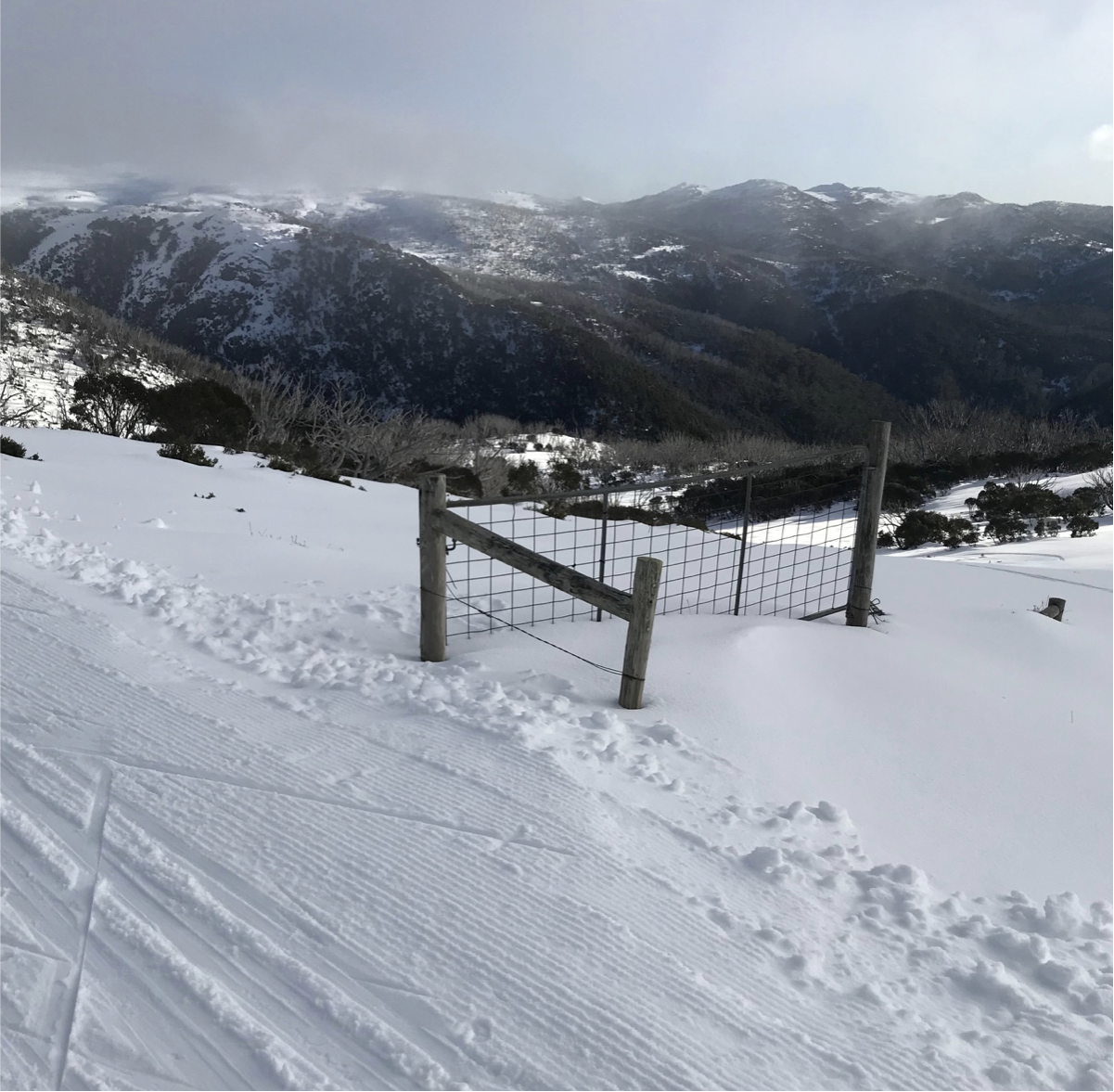
The Cattle Grid is actually just a gate and a fence, you can’t see the buried ‘grid’ in winter.

‘Sinkhole Left’ in fresh conditions. As seen from the road just beyond the gate structure… Click to enlarge
Immediately behind to the gate structure is a long open glade and 50m west of the gate structure is another open glade. They are separated by a treed ridge. The two glade runs and the ridge are known as the ‘Sink Hole Gullies’, left and right respectively. 180m of vert in just over 1km of skiing.
These are awesome intermediate backcountry ski runs, both with unique characteristics. ‘The Left’ is good in fresh conditions, ‘The Right’ is for spring conditions. For full value, on the approach to the saddle gain the highest ground at North Knoll and connect the gullies with the summit. Ski ‘em all the way to the valley floor below at 1620m where the pitch steepens and the trees close out.

Damsite Hill
From the bottom of the Sink Hole Gullies head up the broad valley in a south / south east direction, favouring the right side of the valley and gradually ascending the treed slope. This north east facing slope is Damsite Hill. Damsite hill is not a big drawcard destination of the Vic Alps, far from it. One half has been quarried by the Hydro scheme. Yet it is bigger than it looks and offers plenty of aspects to find fun. If the conditions aren’t with you, by all means skip this leg. We figure, you have to transition to get to the hut, may as well get a little extra vert, hence its inclusion here.
From the summit of Damsite hill transition and you are ultimately aiming for the Pretty Valley Hut, 500m across the valley in a south - south east direction. The important part is to not ski off the quarry cliffs on the south west side, and end up west of the vague saddle where the road crosses the valley such that you get closer to the hut.
Pretty Valley Hut

The Pretty Valley Hut is mainly a veranda, with just a small ‘hydro scheme’ style hut within. The drawcard is the pot belly stove. For overnighters this provides dryness and snow melting. Currently (July 2022) there’s a very small cohort of people using the hut on a near permanent basis. Tents parked out the front, hut stacked with food and gas. This is the product of the huts vicinity to the summer road (40m) and people caching stuff there. As a visitor you’ve as much right to the use of the facility as anyone else, so go right ahead and make yourself a spot by the stove and warm up.

Pretty Valley Hut. You can follow a hut review here with @Bretto
Again for reference for overnighters, the treed area above and behind the hut has sheltered flat sites. When the nor-westerlies blow, this place is pretty exposed so dig right in and find those lee aspects for warmth and shelter.
For the pulk haulers it’s best to explore Tank Hill and the Knobs using pretty valley Hut as a base, rather than hauling back and out along the road to windy corner.
Tank Hill
From the front of the hut, looking east, there is a densely treed ridgeline. This is Tank Hill. Somewhere up there, obscured by the trees is a big ol’ piece of hydro infrastructure in the form of a 30m diameter water tank, hence the name. Sometimes people stumble over it on the ascent, if you do, it means that you’ve climbed too steeply out of Pretty Valley and the dense snow gums are hard to navigate. On this next leg the key is to stay low until you’ve gained the skier right hand, south most toe of the ridge. Ski along the flat a little and then as you can see the trees opening up make for the ridge. Established on the broad treed ridge, navigate up to the first false summit, then beyond to the craggy top. From the high point you can look down and south west to ‘The Tank’.
Transition here at the top, and head off in the opposite direction to the ascent pointing north east. Here the aim is to make it beyond the saddle in the upper Rocky Creek headwaters and there is subtle spur here that if you keep to your right you will end up at out of the trees back and in the basin of the headwaters.
West Knob
Looking south east from the creek uphill sits a craggy lightly treed hillside, West Knob. Scoot directly up the face. At the top the summit extends as a ridge in an eastward direction. Swagger over to the end and transition in preparation for the last drop of the tour. From here the route heads down in a north east direction. Everywhere north east of the summit drains to the creek and the bridge down by the shore of Rocky Valley Dam. Ideally, for the longest drop and closest landing to the bridge, most parties aim for the North Knob creek, beyond the ridge skiers right at mid slope at elevation 1720m.
At the bottom cross the bridge and head back to Windy Corner.
Dirtbag Highway: Road 24

A useful addition to the above itinerary is the inclusion of the Road 24 route. This connects Howmans Gap, below the resort entrance gate, with the Cattle Grid. This is an access route for the shrewd set in the backcountry crew. If you are headed in for a long stay its economically pretty advantageous to hike the road and ‘save the dough’. Be sure that if you park anywhere along the road the RMB will exact their revenge with fines far exceeding your saving, so arrange a car park below the gate and not on the road.
The numbers are simple. Travelling 8km, from 1240m to 1770m is 660m of elevation gain. That’s a biggie. The travel uphill is a straight forward endurance grind. The incline is pretty mellow (you might prefer it steeper) for the first 6km, then as the legs are starting to feel it, you launch straight up the front of Mt McKay in a series of zig zags, the first on the road, the last on the old cattle droving track. A narrow and challenging climb. In anything but ideal travelling conditions the last bit should be avoided by continuing via the road all the way to the top and backtracking around.
However, a truly shrewd option is to bus out of Mt Beauty all the way to the resort, then ski out down Road 24 for the daily 5pm service back to the valley (call them to confirm a Howmans Gap pick-up) . This descent rivals Mt Stirling as the longest road descent in the Vic Alps. A bit of a hoot with a low snowline. A bit of a hike out if the snowline is higher.
For people residing at the resort, the complimentary bus service can be called by the staff at the gate for the return trip back up to the resort.