Falls Creek: Watchbed Creek via East Heathy Glades

The view North East from Nameless Knoll across the Watchbed Creek valley with Hollonds Knob on the horizon.


When you are starting out in the backcountry, once you have got ‘the bug’, you dream of somewhere hidden away, with a smorgasbord of slope angles and aspects. Fresh water and sheltered campsites as a base too while away the days exploring. That secret spot is Watchbed Creek. Google it! Nothing comes up? Yep… this is a scoop.
The geography of this destination favours good amounts of snow deposition (read stashes) relative to the surrounding area. In mid winter, many parties cruise beyond the ‘Watchbed’ only to miss the good bit and end up on vast, exposed, scoured and icy alpine terrain on Mt Nelse and around Edmonsons Hut. The hot tip is stay below the treeline and enjoy the shelter. Save the alpine terrain for spring in this area.

This tour starts out from Windy Corner Car park. Windy Corner is located at the end of the road at Falls Creek Alpine Resort. Parking here will require an entry fee for as many days as you are visiting. The resort entrance is at Howman’s Gap 6km down the road. Howmans Gap is also the location of the YMCA centre and a very ‘Backcountry Friendly’ venue to base yourself from prior to and following your tour if needed. Accomodation is dorm style cheap and cheery and the perfect place to use as a base for adventures in this area. More info here: https://camps.ymca.org.au/howmans-gap-alpine-centre

Lucky for you, the SES Alpine Rescue team are based at Windy Corner. This is a key factor in being able to provide what is a pretty adventurous ‘introductory’ tour itinerary. If something goes wrong, rescue resources are close at hand. As always call 000 on mobile, request ‘rescue’ and then follow the instructions. Falls Creek ski patrol are ready at hand also within the vicinity of the resort boundary (up to the dam wall), so if you are feeling broken, but not actually broken, call them for assistance: (03) 5758 3502. Mobile reception isn’t great based on most recent observations. If this is the problem dispatch someone to raise the alarm from anywhere with line of site to the resort (Village View Saddle or dam wall).

The tour described here is what we call a ‘Sawtooth Tour’ for the characteristics of your elevation plot at the end of the tour showing distinct ups and downs. This tour is about milking the terrain for the maximum vertical both up and down. Nailing quick transitions and travelling across the country. Not ‘Cross Country (XC)’, those XC trails criss cross the terrain you visit and are a handy exit, but this tour is off piste for the greater portion. There is not any avalanche terrain within the entire valley and as such it is a ‘free for all’ with the tour notes describing the best way to link the ups with long, plush, downs. Treat this as a ‘rough guide’ and make your own terrain choices if you see something particularly tasty. Suitable only for either alpine touring, telemark or split-boards, with skins (and crampons if its icy) all round… not ‘light tour’ or ‘XC’.
This tour is flanked on all sides by groomed trails. All trails ultimately head back to Falls Creek in a North or West direction. The XC trails (not formed roads) are the Hoppet Racecourse. There is etiquette at play on these trails. Keep to the side unless you are ‘skating’ (side to side skiing motion), or just generally stay out of the way of slick fit people in lycra, they get shouty.
You can do this tour in either direction. Or better still travel out and back ‘the hard way’. If the snow is fresh, the groomed road might provide more glide than the ‘wild snow’ for the way home.
Generally the Bogong Highplains are renowned for the some poor surface conditions (rime ice and freeze/thaw crusts) however the terrain does not have any high consequence (Fatal) fall zones, regardless always arrest even short falls on ice. Falling into creeks (melt wells) is a real problem here so keep a good eye out. Snow bridges require diligent assessment before crossing, and if in doubt find another option.
Camping
The area immediately beyond the dam wall is popular with school groups doing snow camping expeditions which speaks to the suitability of the venue for ‘first time snow camping’. There are plenty of sheltered camping spots amongst the snowgums low in the valley. These options are marked on the map. If this is your parties first time snow camping, a better option is to follow the ‘flat-out’ described as your approach, set up camp in the upper Watchbed Creek valley and tour the area without your overnight equipment on your back. One strict obligation out here is the use of ‘poo tubes’. You must carry out, everything you take in, including your poop. Instructions here!
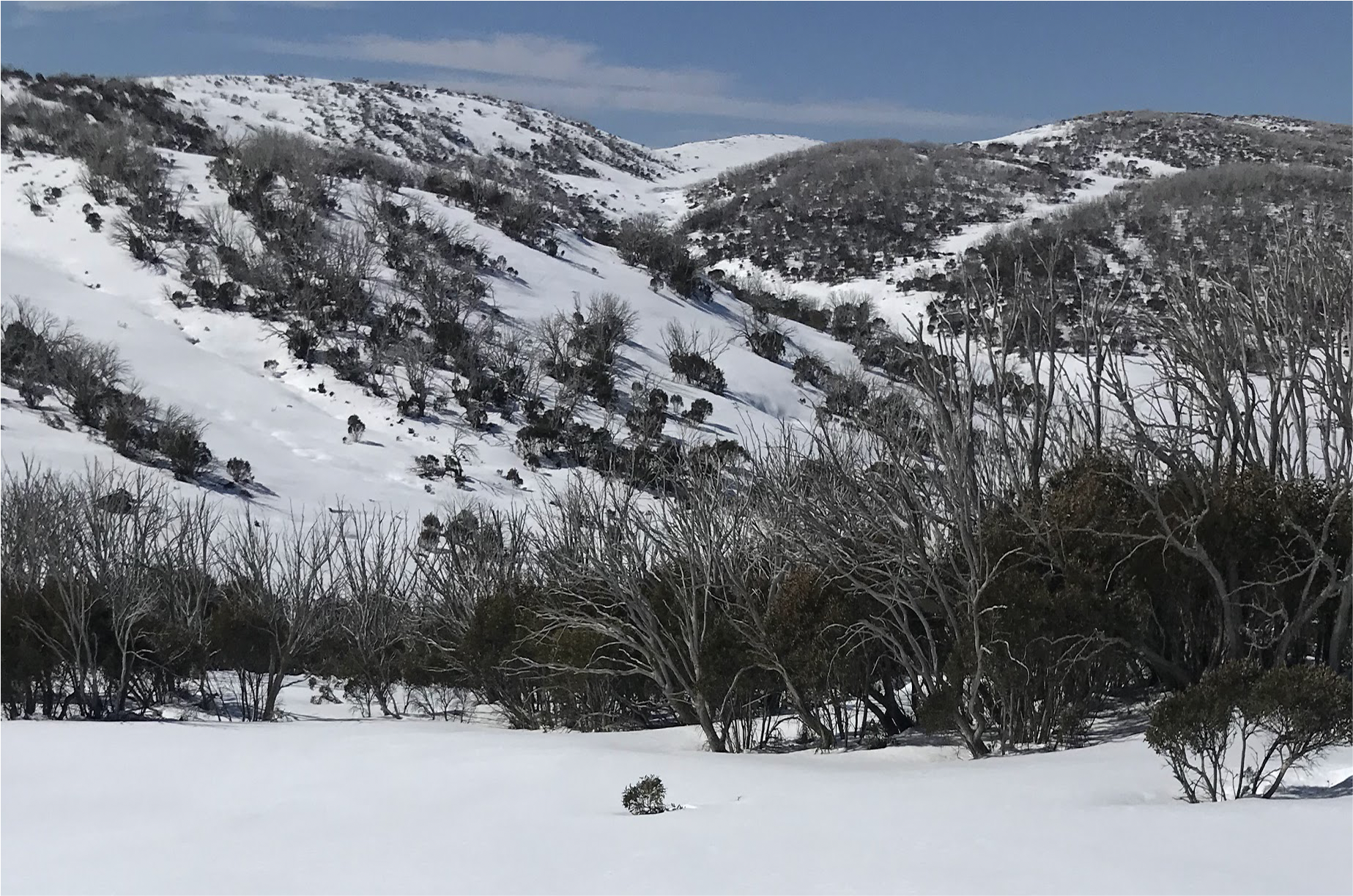
Watchbed valley from Nameless Knoll
Bogong High Plains Road: Windy Corner to the Dam Wall
Once you have assembled at the trail head, nice and early ready for a big tour (8am is a good start time). Skins on and uphill mode ready, head out along the Bogong High Plains Road (BHP RD), in a southerly direction. This is pretty straight forward, being mind full not to take up trail space for the XC scene. Eventually you will come to the Nordic Bowl. This is a place where the XC races are staged. Scootch through the bowl and exit the other side on the broad South West trail signposted ‘Dam Wall’. Soon after you can see the wall and the where the trail crosses. Gain as the various trails converge with the Bogong High Plains Road again to cross on top the Dam Wall.
Parks Shelter to Village View Saddle
Having crossed the Dam Wall, dead ahead is the Parks Victoria intentions book and shelter. Fill out your intentions with all the relevant details. Now turn South East and follow the BHP RD only 100m before launching uphill on the skiers left. More often than to there will be tracks, if its fresh snow, perhaps not. You ascend this slope aiming for the ridge at a point at elevation 1660m above the road. This is Village View Saddle. You will find a groomed trail i the vicinity heading up and west to the top. From here the tour drops back down to the road. Transition here and make a long Eastward slowly descending arc aiming for the bottom of the south facing hills side / bank. The longer the better as it saves distance on the flat before the next ascent!

Leaving the beach… looking back, whilst heading up, from the Dam Wall to Village view. Crunchy early morning crusts may have you reaching for your crampons early…
To Nameless Knob and beyond
With any luck you will have landed back on the BHP Rd near a frosty little south facing embankment and a stream just immediately West of it. Use the Gaia plot to reckon your position here. From here, transition to up hill mode, travel just another 50m where the road turn South East and instead climb up off the road to follow a Westward bearing. A grove of gums borders the skiers left side of a glade that extends up out of sight on an North East bearing. Travel up this glade for 100m vertical to elevation 1700m.

View of the shoulder on ‘Nameless’. You should emerge from the BHP rd somewhere on the top right of the shot.
This is the shoulder of Nameless Knob, named coincidentally due to its prominence for this tour as a navigational location. Open to suggestions.
Transition here, eye your line and again, make a long arcing Westward descent to the valley floor. Staying just below the verge of the gum groves. Watch out for melt wells where the creek is exposed in small circular holes, often meters deep in places.

Skiers view from the shoulder of Nameless looking North East. Your aiming for the flat distant snowpatch on the right of frame.
If when you get to the bottom of this fun little run and loved it, by all means ‘lap it up’ then head back from here.
Watchbed Creek
Once back down at elevation 1630m -1650m you are in the Watchbed Creek basin. If camping then anywhere up stream from here there are plenty of sheltered spots to build camp up near the Gum groves on the west side. Day trip parties will want to be heading up again here no later than around 2:30pm as the return time is 3:00 for you and its still a long way home.
The west side of the valley offers some great tree skiing from as high as 1750m (100m Vertical) from here. On the opposite side of the valley (across the road), you will find a gentle bowl known as ‘the stock route’. Lots of fun terrain all round. Many an afternoon has been spent by parties sampling the slopes all the way from here back and beyond Nameless Knob.
‘Flat-Out’ to Windy Corner.
If the team is flagging and you are looking for an easy way back to Windy Corner simply turn back along the BHP rd. From Watchbed Creek the road on the East side of of the valley descends to the BHP Rd, where heading west from the junction / bridge will have you travelling along the flat road that boarders the lake to the Dam Wall. The Gaia plot also shows a route following the West bank of the creek back to the BHP rd which cuts a bit of a corner, but is not generally faster unless you have a bullet proof crust. Dont forget to tick yourself off at the intention book.