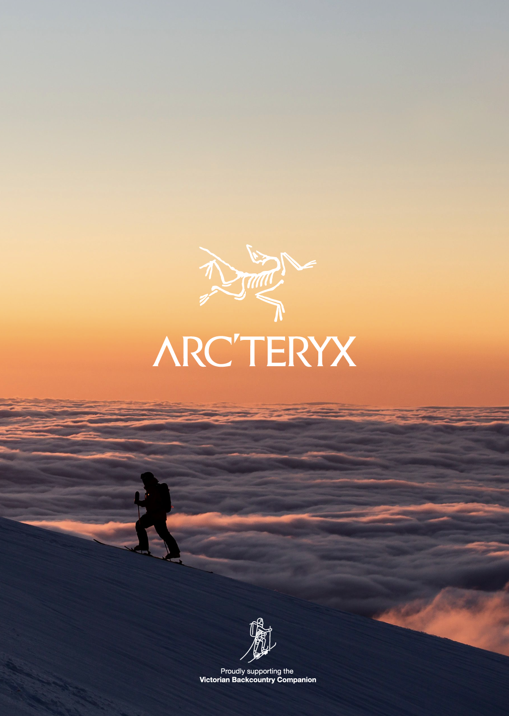
The Fainters via Jaitmathang

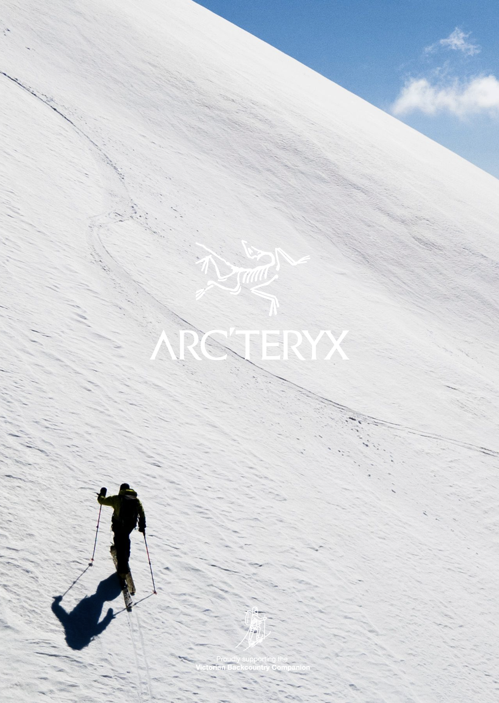
The Fainters as viewed from Machinery Spur with North Peak (left) and South Peak (far right) and the South West Spur heading down left below the outcrop (Castle Greyskull). Notice the complex cross loading patterns on the spur and the ‘upwind’ features of the North Peaks south aspects.


Presumably Wilkinson and Docherty from Harry Stephensons tome ‘Skiing the high plains’
The tour to Mount Fainter via the Jaitmathangs presents a long and varied journey, first skied back in 1927 by two blokes Wilkinson and Docherty, accessed from Omeo via Kelly’s Hut. The route followed here retraces much of that original high ground via ‘Wilkinsons Lead’.
At over 18km and over 1400m vert as a outward journey this is two ‘Razorbacks’ long. You will traverse wooded glades, scoured and corniced ridges and experience truely remote camping high on the range with vistas from Kossi to The Bluff. Importantly, the way this tour is described it provides long ascents and descents making it perfect for split or alpine touring. Sure there are a few flats to be crossed yet no more than a half kilometre here and there. These are more than compensated for by the unique and remote delights of this wild area. In addition to this, for the first part it’s possible to sled / pulk your load to the neat, newish huts at Tawonga gap, and enjoy a few extra camp goodies.
This route starts from the Pretty Valley Hut, so follow the Companions tour notes to there and then use the ‘Jaitmathang’ GPS plot to get to Tawonga Huts. Wilkinsons Lead starts from here. We’ve included a day tour notes for the local delights of the Tawonga Huts too.

This tour starts out from Windy Corner Car park. Windy Corner is located at the end of the road at Falls Creek Alpine Resort. Parking here will require an entry fee for as many days as you are visiting. The resort entrance is at Howmans Gap 6km down the road. Howmans Gap is also the location of the YMCA centre and a very ‘Backcountry Friendly’ venue to base yourself from prior to and following your tour if needed. Accommodation is dorm style, cheap and cheery and the perfect place to use as a base for adventures in this area. More info here: https://camps.ymca.org.au/howmans-gap-alpine-centre

Whilst the distances travelled in the tour notes have you in a remote area, fortuitously the SES Alpine Rescue team are based at Windy Corner. If something goes wrong, rescue resources are close at hand. As always, call 000 on mobile, request ‘rescue’ and then follow the instructions. Falls Creek Ski Patrol are ready at hand within the vicinity of the resort boundary signposted with the Parks sign on the road. The Fainters Fire Trail will be the most practical escape route in the event of an emergency and runs parallel to the routes described. The exception to this would be if an incident occurred on the west side of the range which is coincidentally where the steeper aesthetic ‘big lines’ are. It’s likely that an ‘up and out’ rescue would be the best extraction. This would likely be done with VicPol/SES and Falls Ski Patrol in concert as the patrollers are the steep snow extraction experts. You will have to explain the scenario and ask very nicely if Matt O’keefe is available.

The tour is described to suit alpine touring, NTN telemark and split-boarding disciplines. As an advanced tour the notes describe travelling through avalanche terrain and with that falls the responsibility that parties need to know the ‘rules of engagement’ and keep themselves safe. Check the forecast. The main challenges are the approaches to the South Fainter summit and most stuff facing west and south. The snowpack here is characteristically cross loaded so the absence of cornices at ridge top is not an indicator that a slope is not windloaded. Also the ‘South Side’ bowl on Jaitmathang slides naturally quite regularly after storms. Also, widespread ice and robust crusts (early morning and early afternoon) will require ski crampons to be carried.

This tour requires some significant navigational nous. You will need to follow bearings for long distances in exposed areas without any other reckoning than your altitude, and alternatively make use of ridgetop handrails that can at times be complex or obscure. From the summit of Jaitmathang the route forward along the ridge has you ‘dog legging’ backwards for 50m as an example. In a whiteout the Fainters Firetrail is another convenient handrail although often hard to locate without GPS in a deep snow. Don’t be intimidated but do take your time.
Pretty Valley Road.
As you enter the flat area of the Cattle Grid ‘Gap’ you will have joined Pretty Valley Road just short of the gate heading SSW and the Mt McKay road heading NW. On a clear day from here your tour is visible down into pretty valley to the immediate SW with ‘Pretty Face’ beyond (obscured by Damsite Hill), Jaitmathang (pronounced ‘Yamatang’) behind that and lookers right (West) is Mt Fainter North and South Peak. Mount Feathertop peaks over the top behind ‘Strange Point’. It’s worthwhile studying the route from here if you are blessed with visibility. If the wind is up, scootch on through this hostile corner and head past the gate/grid for shelter behind cliffs on the roadside 50m away on bearing SSE (157˚). The ‘Gap’ is last Mobile reception until you come into range of Mt Hotham beyond Pretty Valley on Coopers Knoll.
From the cliffs on the left of the road the area below and lookers right is known as the Sink Hole Gully, If time and daylight is running out and a quick sheltered camp is required you can duck down this delightful glade area for sheltered treed flats just lee of the spur about 50m vert above the true valley floor. For more proficient skiers it is an option to add a bit of extra vert by heading down to the bottom of the sink hole gully where it joins the main drainage below Mt McKay and then transitioning and skinning back out to Pretty Valley road on a bearing ESE (112˚) to rejoin the road (or the xc loop if its groomed) on the eastern flanks of the Pretty Valley Pondage.
Most parties stick to the road and follow it gently SSE for roughly 1km to the junction and the National Parks sign. Again, if its late then shelter is another kilometre along the left fork at the Pretty Valley Hut (see description below). If the party is strong and the weather is fair then take the right fork as it cuts in under the stepped ‘Quarry Face’ of Damsite Hill, then pick up the pondage flats and make sure you end up on the south east shore and skirt the water across the flats. Following the road around to the dam wall is a huge fail, passage is blocked by gnarly fast water and steep embankments… stay east of the water as you head south.
Pretty Valley Hut.
Nestled (obscured from the road) on the east side of the Pretty Valley Road is the Pretty Valley Hut. It’s a shelter really, a small Hut within a shelter is perhaps a better description. It’s big enough for 6 people to cook and stand by the pot belly and dry out / warm up. Yep folks, standing. You could seat perhaps 4 people with packs and stuff? It’s small… The area around is exposed to the south and west so be aware, whilst it is shelter, it is not palatial. A long drop toilet stands across the road at ‘the Stockyard’.
Pretty Valley Pondage Causeway - WSW (247˚) to Cooper Knoll 1820m.
All roads lead to the causeway wether you cut the corner and skirted the shore, or came around past the stock yard (taking all right hand forks / not the pole line to Cope Saddle). The Causeway marks the start of the real deal backcountry experience. Once on the other side you will need your navigation skills as you are following a bearing for a 2km ascent of 200m vert, and then 180m descent over 1km beyond, all on that same bearing. Head WSW (247˚) from the end of the causeway you should after almost an hour of solid skinning up a huge gentle bowl skirted on the lookers right by a corniced ridge, arrive at large flat high point with an inconspicuous summit, Coopers Knoll (1820). A rocky protrusion with an ancient snow gum. If the weather was bad half way up, then it will be appalling by the time you get to the flat top. keep on following that bearing and with any luck, as you notice that you are heading down hill and beginning to glide on your skins, then you will be in the vicinity of Ben’s Cairn or the Memorial Cairn. Transition if you haven’t already and keep on going WSW (247˚). As you get down to elevation 1700m you’d be hoping to soon intersect with a pole line running NW/SE. This pole line descends into Tawonga Gap, and the huts. If you ended up too far north and in the glades, battle down to the flats and across the creek, to warmth and comfort.

The main ‘Mess’ Hut at Tawonga has a new firebox heater in it which is a huge step forward given that without it the hut was impossibly smoky when the wind blew. There are three other huts as this location, one on the right of the shot is also pretty good without a fire. To the left of shot is an ‘accomodation’ hut. With large bed ledges on it, this is obviously purpose built for sleeping in, and we are having trouble leaving you to read between the lines on that. Always carry a tent regardless. The toilet is just uphill from the accomodation.
Tawonga Huts and Environs.
The human habitation of the Tawonga area is known to well and truely pre-date white settlers, buy at least a dozen or so thousand years. There is lots of lore and custom associated with this area with many people, of many language groups over a long time. The reason was gatherings and feasting, on Bogong Moth and game. Culturally we understand this to have been a seasonal event and by the local indigenous calendar is assumed to occurs after the snows.
In post-colonial folk lore it is believed that the Kelly Gang wintered here in 1878 as they fled the ovens valley and the charges, warrants and mothers that awaited them. Dining on their horses until the snows cleared and then walked out down the West Kiewa to their fateful demise at Glenrowan only a year later.

Skiing around the Hut
South and East of the hut is the Home Run area, a glade skiers delight within easy striking distance of the front step of the hut. Also the slope back up to Coopers Knoll is an enjoyable place to while away a sunny afternoon. West of Coopers Knoll are some interesting little gullys and drops into the area marked on old maps as ‘Terrible Hollow’ which sounds desperate so perhaps pull up before that.
Fainter Fire Trail
From the ‘Mess’ Hut, looking North across the flat on the side of the Doe Hill on the same contour as the hut, exists the Fainter Fire Trail. In a good season, the snow drifting on the track combined with fallen dead timber and whatever else mother nature is using to disguise its presence, it is hard to find initially (Use the GPS). It’s a long flat contour around the whole Jaitmathang massif that eventually leads up to the summit of the Fainters. For the most part, far from exciting stuff yet kinda worth noting because if the weather is socked in you can sneak out along it, Some of the drainages off Jaitmathang which cross it and head down into ‘Terrible Hollow’. And when your smashed and exhausted from a big day on Fainter you can use it as a handrail to crawl home. If you know where it is.

TOUR NOTES 1: Jaitmathang Day Tour and access to Wilkinsons Lead
Victoria’s Secret and the Jaitmathang Creek side of the range at Tawonga.
Parties have done this as a day trip out of Falls Creek, a 12 - 14km journey from the Cattle Grid Gap. We’d suggest pulking your gear into ‘the huts’ and taking the opportunity to spend an evening at Tawonga with this as a day tour itinerary. There is lots to explore and its not limited to skiing.
From the Mess Hut, head west up the broad valley heading to the summit of Jaitmathang. 400m up stream from the huts is an open glade on the right, ascend this to the saddle then follow west again into the forest ascending to 1700m where you can skirt left and leave the broad ridge beside a large boulder heading for the bottom of a widening gully / face. Note that the glade East of this area is Sherbet Creek, a spot worth exploring if the conditions won’t permit travel above the tree line from here.
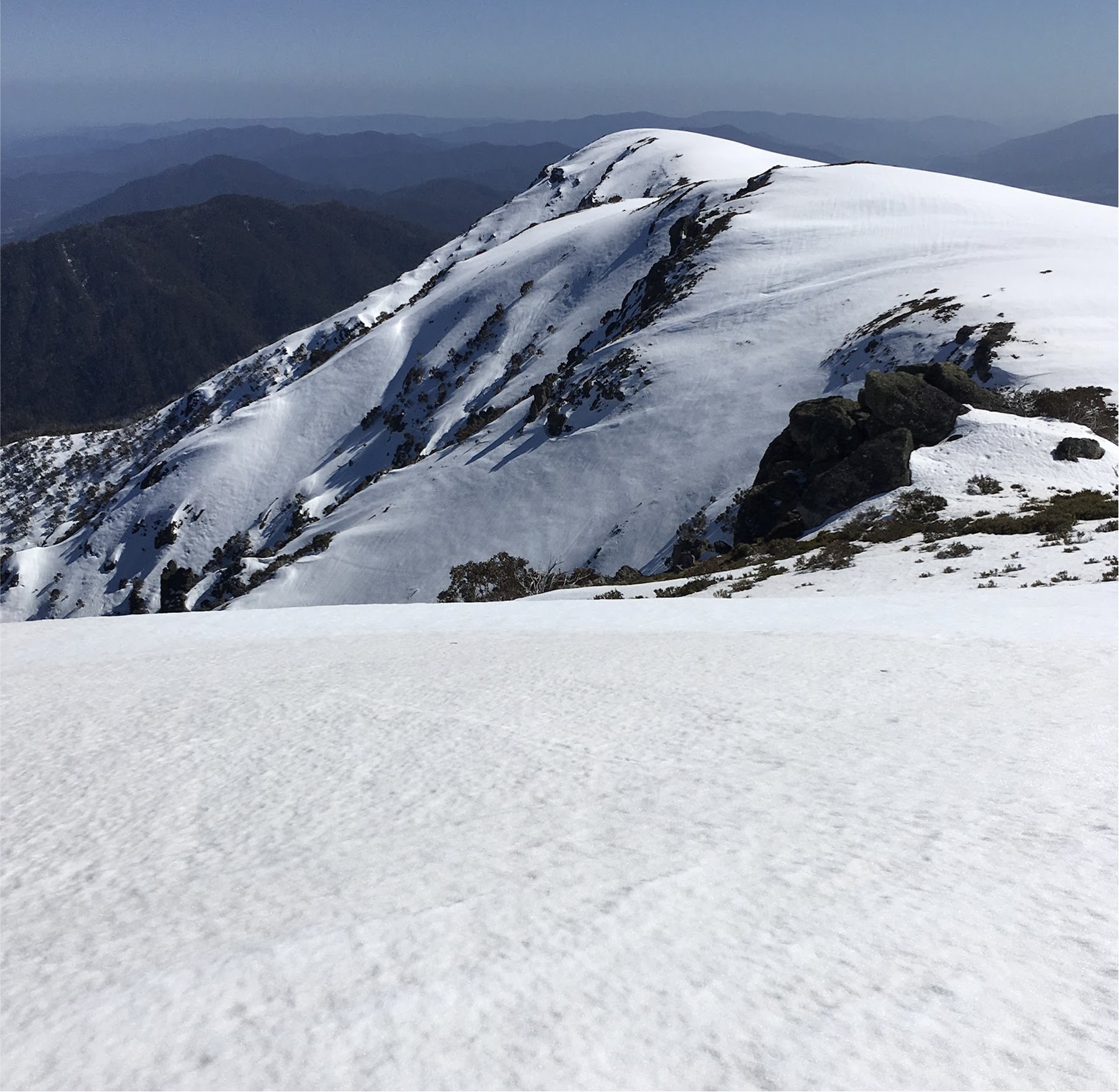
From the boulder, skin upward onto the shoulder East of the obvious summit Cairn. The view across to the East and North faces of Feathertop here are as good as it gets.

Looking West from Mt Jaitmathang at Feathertop. Note the treed glades bottom right of the shot are entry into ‘Promised Lands’ chute.
Promised Lands
Heading West then North from the Summit, across the back of the cairn and out onto the North facing flank you enter into another more alpine and craggy world. This is the start of Wilkinsons Lead for those following that to Mt Fainter, and the branching off point for parties skiing into Promise Land Chute.
Skip and Jump here to the TOUR NOTES 2: Wilkinsons Lead section below if you are headed to The Fainters
The West aspect of Jaitmathang summit drains into a long and steep moraine field. In summer this is a Bogong Moth Mecca and on that religious note you are travelling into lands steeped in cultural significance for traditional owners. Not to mention prime habitat for the critically endangered Pygmy Possum, so it goes without saying, be respectful. The name tips it’s hat to unseeded sovereignty, so take a moment to reflect as you transition to downhill.
Skiing north and then arcing west the pitch increases as you pass beneath a series of cliffs and turrets on the right as the main chute presents itself. As the pitch gets up beyond 20˚ it’s worth putting the avalanche hat on and assessing the snowpack to make sure it is stable, ski one at a time and stop in safe spots. In the event that something goes wrong down here, there is an old overgrown logging track 600km down hill from the bottom of the morraine, then the West Kiewa road another 300m below that . We explored this as an alternative approach and with a bit of work it could be realistic. Tough country now though.

Skiing this line in friendly spring corn snow down to the flowering wattles and the sound of the rushing West Kiewa not too distant below, with Feathertops grand North Face towering across the valley, is truely a rite of passage in the Victorian Backcountry journey. And for the authors, a cultural one, a journey of recognition to all those who have travelled here before.
While in the culture space, the craggy rise above the Promised Land is the realm of Dulugar, named after the traditional equivalent of the nordic Thor, a Thunder Lord! but not the Marvel version, less benevolent and perhaps even demonic? Catch this little clip about the spirit lord of this area, and on top of the hill look at the work the lightning has done pulverising the rocks… Dulugar waz ere!
There are other interesting features in this area. Everything north of Dulugar on the west side of the ridge here is a smorgasbord of unexplored tree chutes and impressive looking crags all the way for 3km to Strange Point and beyond. Go pioneering and report back with what you found.
If the snows not playing along, the ice climbing at Kelvin Crag and the ‘Knuckle Heads’ South Buttress of Jaitmathang itself have lured climber- skiers out here for years. The obvious line (from Hotham) up the Knuckle Heads is an exciting little foray, a promising looking chute, actually choked in stunted snow gums, concludes at an intimidating ramp out onto the prow of the buttress, followed by some steep ground to the gentler summit slopes.

OK, back on the ski trail, transition at the bottom and head back up to the summit, favouring this time a route to the South Summit, the lower, unmarked rise above the craggy faces. Transition at the top for a fun steep little slide to the saddle south between Jaitmathang and the next rise Home Hill. This face can avalanche so make a sound assessment of that hazard before attempting it, or head left down the treed ridge as an alternative.
Then head up onto the next gentle rise, Home Hill, south along the ridge. The top of this provides access to an area known as Victoria’s Secret. This is sexy stuff. Much like the tree area at Hothams ‘Pumphouse Drop’ these glades offer some epic steep deep pow skiing when the temps are low and the precip is high. It was a secret, but now it’s not. Untracked tree chutes for daze.
On the opposite side of this side valley is Westons Hut, which could be a thing to check out as an objective. This is the start of the Five Day Hut-to-Hut tour. Once you are done, head back up to the top and descend the North East aspect of Home Hill to ski down to Tawonga Huts via the glades. Parties regularly spend the rest of the afternoon exploring these glades too.

TOUR NOTES 2: Wilkinsons Lead
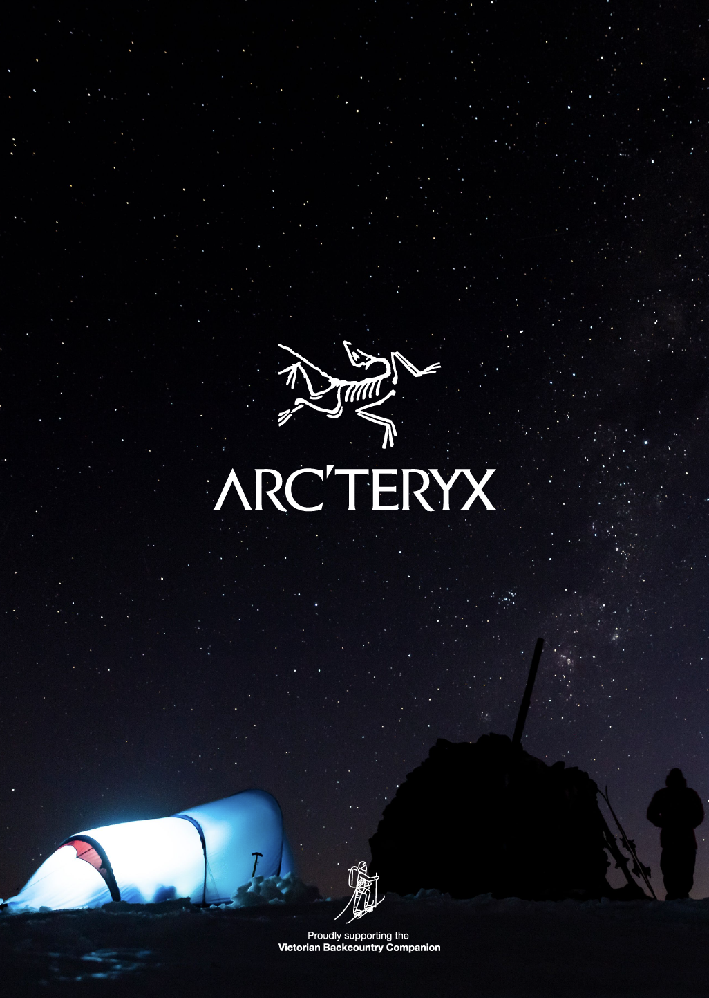
A traverse of Wilkinsons Lead can be done as a ‘big day’ 16km round trip returning via the fire trail, or better, as a lightweight sortie from Tawonga Huts as an overnighter leaving the spare stuff at the huts and travelling light to camp among the snow gums at Salt Camp. Campining out there leaves time to actually explore the steeps on South and North Fainters. This is certainly a ‘fair weather’ objective and near to impassible and dangerous in challenging conditions even by ‘advanced’ standards. Much like the Razorback but maybe more exposed for longer yet with better escape options (along the fire trail).
The GPS plot to here takes an alternative route, up the South East Ridge, same - same but different. From the summit of Mt Jaitmathang head around the back of the cairn to access the top of the north facing aspect, with sparse trees. (Keep skins on for now as its a short drop to a long flat section). If you are stuck in tight trees you haven’t travelled north enough, or past the summit (it is confusing country, particularly in variable visibility).
After the initial short drop, punch across the flat, Northward, for 400m to the top of the mound East of Dulugar. Here, transition to downhill with a twist: Splitboarders will want their stocks, skiers might want skins off with free heels to scootch across the flatter section. Head down favouring the west side (left) of the ridge, whilst treed it provides a more continuous descent. Keeping left of the ridgetop mounds (this is only possible in fair weather, stay right if its a bit wild), to the saddle at 1750m… scootch across this to mount or skirt the last hump on the ridge before the delightful fallline face descent to 1650m in the gully 200m west of ‘Little Plain’. Transition and head up to Little Plain.
Little Plain and Salt Camp
This broad saddle connects the Jaitmathang Massif with the Fainters. Theres an abundance of super cute spots to camp. We always prefer the trees in this vicinity for their shelter and a lil camp fire, other stay up higher, N00m north at Salt Camp. Across the plain to the east is the Fianters Fire Trail and your navigation handrail to escape if the weather changes.
Mt Fainter South Peak 1883m
Ok, the bit that we’ve all been waiting for. Oft viewed from varied vantages across the range, but seldom visited the first view of the peak is actually from mid slope as you shuffle up the side of the bread loaf like summit escarpment above Salt Camp. On the left there the obvious sense that the face descends to deeper depths. ‘Nayled It’ is the ridge in profile immediately to your left. This gentle spur is a great line to ski and scope the surface and features further west. If the summit is the objective, then best tick that first.

There is a simple rule to the lay of the lend that the further west you travel along the summit ridge the more challenging the terrain becomes. The South Face of Fainter South glances the winter sun so its either a powder venue what a storm lifts and you are blessed with a stable snowpack, or a spring thing for early September. The South Ridge descends just west of the summit cairn and gives you a closer look at the bizarre cross loaded lands to the west culminating in ‘Castle Greyskull’ buttress which has been rumoured to have been skied though not much is known about it. The South West spur is a mountaineering objective and sounds like a regular sufferfest albeit with an amazing bivvy atop a turret high above the West Kiewa (this spur is the rocky escarpment visible from downtown Bright) and the route bush bashes up from the West Kiewa Road (Bike access in winter).
Faintly across east to Nayled It would be the place to explore for starters as they all share the same skin trail out to and up a series of benches just left of the treed lower Nayled ridgeline.
Beyond the obvious distraction of the South Face lies more to explore on the high ground connecting South and North Fainters. The ‘Astral Plain’ is indeed quite a heavenly domain with high gentle alpine eastern faces that warm up quick around to the steep western fall which we’d venture is largely unexplored. First tracks galore out here folks. Certainly the only descent out here is the obvious South Face drop on North Fainter. ‘The fin’ like wind lip on the hidden face looks awesome too. Big country, total no fall zone all of it. Like the East Face of Feathertop with less sun so there’s some deep science involved in unlocking the conditions here.

The South faces of Fainter North and South respectively with ski descent overlays.
From the North summit you can see down to Mount Beauty all the way up both the arms of the Kiewa rivers in 360˚ to Mc Kay and the greater expanse of the High Plains beyond. Feathertop and Bogong sit sentry either side at this longitude. Camping up high on the Astral Plain is an option for those ready to brave some high winds should they occur. The bit that is missing in this section is detail on the open easter aspects… its great, but you will have to find out for yourself.
The View from South to North Fainter with the ‘fin’ in the foreground on the left.